
Sharkies Under the Gun

My old surf spot getting rocked today- gave me chills. I hope your safe. St Pete may to have dodged yet another bullet. Some say the indians of IRB have always pushed the hurricanes away from Pinellas and that is the reason why Central Ave sticks out on the map. A more logical explanation is below.
Random Ian Thoughts from 1100 Miles Away: The Live coverage of Ian today is insane, we are going to learn a lot from this one. Maybe some people will get scared and move away from Florida? Naples and Ft Meyers are under a lot water.
This was 3 days ago. IN the comments ‘I like Tweez Ian’ called it 3 days ago. I discounted it but the trough over Michigan got enuf to push Ian east early and the Tampa Bay Area seems to have been spared the worst whereas Ft Myers and Naples are being punished badly by Ian.
Ian Buzz Saw. We would love to hear your experiences with Ian, post up in the comments if you want to vent.
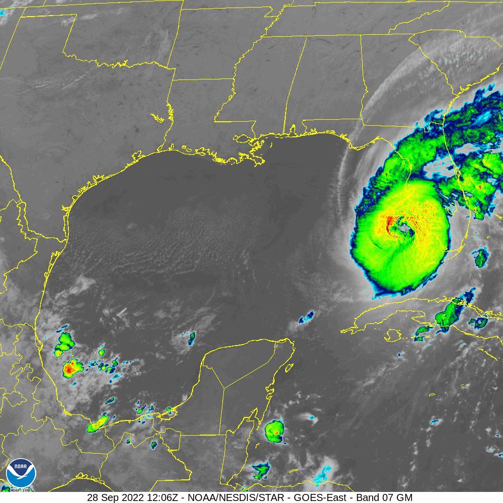
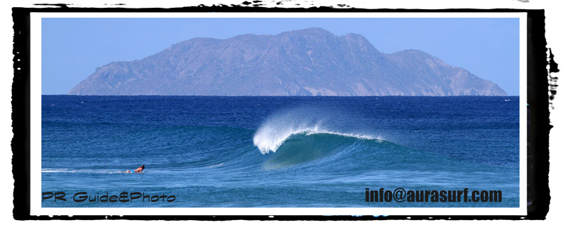
Ian offshore Captiva.

Tuesday am Western Cuba is pretty sparsely populated thankfully. Ian about to enter the GOMEX.
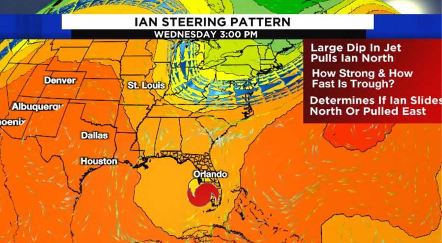
This Monday am EURO model for Thursday. The GFS is not any better…


Need an attorney that understands you? Check in with Scott.
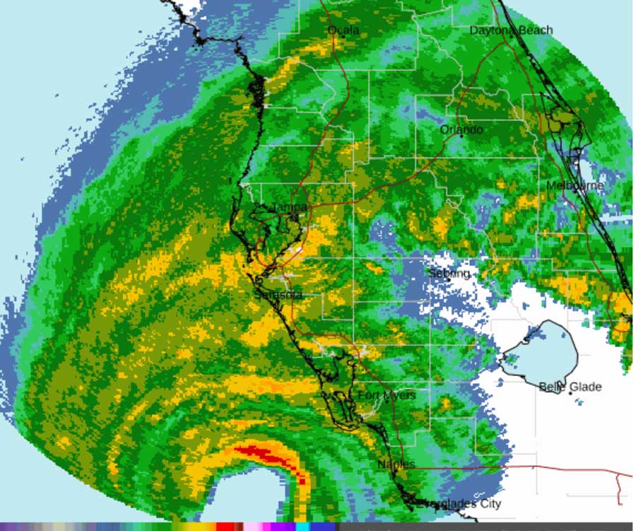
Wednesday Sept 28, 2022 Ian Day: (PR update first) Last night at 8pm we finally got power back after 10 days without. Internet is working also. Thanks to everyone who texted and checked in with us! We are doing better finally… Checking the cams, the only one I saw was Venice and the waves are still small so your not missing anything. Ian is hugging the coast and has not produced much swell. Ian is looking at the Englewood area, may make a new inlet, what a monster. The TB area is on the N side of the storm. Ian is super powerful like Irma in Barbuda, 155 is a crazy buzz saw. Not much positive to take from this but on the back side of Ian this weekend and next week the WX in the Bay area will be cooler and less humid and the worst summer ever will be over finally. Hang in there guys, maybe some cold front waves Friday if they let you back out on the beach, looks waist to chest NW waves, Saturday 1ft range.
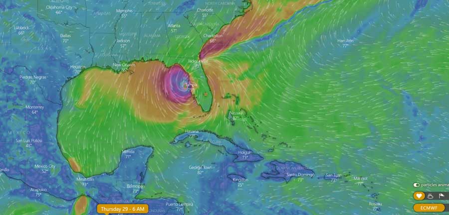
Tuesday 7am Generator Life Update for WFL: It’s south of the bay on both models now which may limit surge in the bay- hunker down. You will see that the worst thing by far about Ian will be the slow fwd speed, like Harvey in Houston it will dump more rain and when you want it to be over you still have another 24-48 hrs of bad WX. Even for those who leave the wait for Ian to exit stage right will be agonizing. Even though the EURO and the GFS have shifted south the official NHC track is still close to Tampa Bay. I imagine that may shift south at 8 or 11am. Partial quote from Tampabay.com this am: ‘It’s time to stop wishing it will go away and start finishing the preparation’. Have an interior safe room in case it gets real bad- and if your in danger of surge like your house is 10ft above sea level or less pick stuff up off the floor. So many people here lose generators and all sorts of machines by leaving them at floor level. If the storm passes to your right I see that as a plus bc the wind will be N and the surge will be limited to begin with. It’s all about where the eye passes and which side of the eye you are on. Looks like Andrew. Homestead got creamed but Miami did not. A tight intense compact storm, past 30 miles from the eye the damage may not be that bad. Finish up guys, the next few days are going to suck, we’re praying for you guys…
Monday WFL take: Before Elena we got a window of waves if your into that but the forecast looks bad, I hope it’s wrong… As soon as Ian clears Cuba and enters the gulf the swell will be on the way with offshore winds in front of it, like 6-10hrs, late Tuesday some 3ft swell lines could arrive before dark…. But it looks bad- hoping for minimal damage but the forecast is not good.. it would be awesome if the front up by Michigan re directed Ian but it’s late September and a week or 2 too early for an early front 90% of the time, La NInya makes that worse and less likely. The GFS is classic over-hype this summer as far as an off season system doing things out of CLIMO- translation: that’s why the EURO has been the go to model since May. This was my experience with a Major Hurricane if you don’t want to hear the nightmare stop reading this now… I’m thinking back 5 years to Maria- when I finally opened the door after 30 hrs of hurricane winds (120miles an hour) the landscape around my house looked like a black and white version of a World War II battlefield, not a lief on a tree. Huge old Mango trees laying on their sides, roofs ripped apart, it was really bad, I felt nauseous like I had been gut punched. I hope you guys don’t get the worst case scenario. The nice thing was afterwards neighbors helping each other and everyone getting to work putting things back together. 7 days after the destruction an old Quenepa tree that is 50ft tall and a 100 yrs old and has seen many hurricanes, it sprouted beautiful, bright green leaves and gave us hope that life would some day get back to enjoyable. I’m praying for you guys. If any of my friends in Seminole want to stop by my parents house near the Twistie Treat Ice Cream cone and check in on them before or after the storm e mail me and Ill get you the pin. They are 78 and cancer survivors and I woke up worried about them early. Wish I could be there to help but I’m up to my neck post Fiona here in Puerto Rico, still no electricity. Alright guys finish your prep and get ready to get outta town or hunker down!
Sunday 7am WFL Non Take A little better news today as the NHC track has shifted offshore. They really don’t know, they are completely relying on the models. Why? They couldn’t even find a center for Ian, he’s basically a struggling little low pressure right now. So if you can’t find the center then it’s really hard to know where he’s going. 200NM margin of error they said. The EURO which pegged Fiona, still wants to bring a strong hurricane up Tampa Bay. The GFS keeps it offshore. Strange that after following the EURO all summer we deviate from it now. Lets all pray the EURO is wrong. That’s all I got today. Summary: Nobody knows what will happen with Ian. There are so many things in play and no center…
Go Bucs… It’s all up to the D and Cole Beasley is the perfect WR for the job if he gets up to speed.
Saturday Quickie: You guys have seen the NHC track it’s been steady for 24hrs at least. The NHC said in it’s morning discussion that the 72-120spread could be 180 miles so they are not putting any guarantee on that track. How do you prepare for that? Seems like a lot of folks in Florida board up and get the heck out. That’s a luxury we don’t have on an island. Hurricane’s suck bro, Puerto Rico is misery right now, no-one has any electricity, internet, barely water and no one knows when the private company LUMA will get it back up, seems that they don’t know what they are doing and they are in over their heads. The people doing well right now with little stress are the people off grid with their own rain reserves. For WFL: In the past when Pt Charlotte got hit by Charlie or SRQ got hit by a storm you know the drill- flooding to the south of the storm to the north of the storm not so much. The farther south the better right? Let it wash thru the Everglades. A Big Bend storm is bad for everybody. If you want to comment on the models and or your preparation, post up in the comments. As for surf, I was 15 when Elena hit and we surfed for 2 days before the storm, good waves. Going to be maybe a brief window of waves to surf. Will you even be able to surf or get to the beach or even want to? I was so depressed for 2 days after Fiona I did not care about surfing but the waves are good now. Hoping for the best guys. Sorry for my crappy reports. I dont even have enough internet to look at the models. Maybe if I go to a cafe later I can update.
Yesterday I spent the day going thru 3 generators. Results: Fridage is 66 degrees, throw the meat out… My Honeywell Generator of 12 years which got us thru Sandy and Maria finally took a dump, a buddy loaned me a new one that didn’t work then I ended up going to Home Depot at 9 at night and getting the biggest Ryobi they had, dont laugh it’s working great so far(6500watts). On the way home we needed gas so I waited in line for almost an hour to get gas, only 1 station was open. Fiona has cost us $1000’s so far, thanks to the guys who donated, helps so much! So thats what it’s been like. At Least the kickback from Fiona has been good and I’ve been surfing with my kids, chest to shoulder high swell- stay away from Domes there is a sewer leak… That’s the latest…
Friday 3pm WFL Update: My parents live in Seminole so I’m nervous for them. I’m at a fast food restaurant right now writing this bc it’s the only place with hi speed internet. Both the GFS and EURO have trended east but the scary thing to me is: what is steering this thing? Will it scoot under the High or get pushed west? Wouldn’t that be CLIMO? But the models insist on bringing it to Florida. Sorry for the late update. We have no power and no internet here 5 days after Fiona. I’ll try and update tonight. Watch Levi, he’s always got a solid take. Check your stuff at least if it did happen you got a few days to get ready.
Thursday WFL Updater 7am: This am it’s 78 in St Pete with a dew point of 76! That is muggy! Heat Advisories are up here in PR also as we have light SE flow and finally drier air in the upper atmosphere, still humid, the sun is out finally for all the solar people off the grid. So steamy everywhere. This am the EURO takes 98L the hurricane just offshore WFL Elena style like we talked about yesterday. The GFS keeps it out in the GOMEX. This is like Tuesday/Wednesday NEXT week. At Least the EURO does not have a land falling hurricane in SW Florida. If you base your future thoughts on the EURO that model completely pegged Fiona’s track along the south coast of PR 72-96hrs out so keep an eye on the EURO as we get closer. Is it still as hot as it was last month? Looks like an extended summer which is bad news for Aaron Rodgers, lets melt that guy!!! More tomorrow… BTW swell would come up for WFL Tuesday/Wednesday next week, more later…
Wednesday 9/21 WFL Wave WX Outlook 8am Generator Powered, Phone Tethered Report(just my take, make your own decisions) GM guys, trying to get back to work, get a sense of normalcy and routine to this crazy Caribbean life. Here’s my take on 98L: Lets go back and look what happened to Fiona- The EURO pretty much nailed the Fiona track but not the strength. The GFS was a little better on the strength but missed the track bad. With 98L The EURO has it going into Naples WFL as a hurricane, don’t freak out. This is like 7-8 days from now. The GFS has 98L headed to Louisiana, classic track and swell for WFL. If you split the difference you have an Elena 85′ style storm in the Big Bend. Lets not get ahead of ourselves. 98L to me does not look impressive on satellite today and many storms have taken dumps this season despite what the models say. Speaking from experience- you should check your supplies, if something did come your way- your getting a super early warning that may be nothing but it’s always good to be prepared. By this weekend you could get a more solid handle on it. Button up your stuff and start driving north. I’m not telling you what to do, it’s just an idea bc this sucks what PR/DR is going thru right now.

info@aurasurf.com
just a word of warning: i live on mckay bay in tampa and eta gave us 6-8 inches of water in my house. a strong storm making landfall anywhere in the big bend if it approaches the coast from offshore and kinda heads towards our way will make much more surge locally than you think. (and that counts for the pocket just east of the cape if its strong enough) if you live in st pete or south tampa the barrier islands or anywhere near your life will be in danger if its a hurricane.
td 9 blob formed and northerly center / easterly track trending…
thanks hd- kind of sketchy- hoping for waves and not destruction but the models are nudging it east.
post your takes here, thanks!
yea its starting to look really sketch for wfl. be safe yall this shit will be really serious for alot of people and will change their lives.
Not excited for a hit. Hoping it keeps tracking west. Went out for tapcons, 30 gallon jugs, tarps, and dry food yesterday. Hope we get a good window at least if we are taking a Crack.
On another note, tampans are complacent. It’s been too long for us and I think we will get caught off guard eventually.
Still a lot of room for changes, NHC 4-5 day track error is still up to 150 nautical miles. Models aren’t in agreement yet and keep changing. That being said, the 3 day error is only 50nm and if it’s still pointed at us Sunday 8pm I’ll be pretty confident we (The Royal We…Tampa Bay North & South) will get worked. Not wishing it on anyone but the more North and West, the better our surfing opportunities. Anyone remember Ivan? Otherwise, we may get a quick window Tue pm before SHTF. 5pm track looking interesting….
a little farther offshore- why does is go from a major to a hurricane? something knocking it back? that is critical- if it’s weakening that would be a plus for sure, don’t bank on it but hope it is not a major
Apparently increased shear the further west and north it is.
7 am est its about to get a somewhat southwesterly core and its still moving pretty westerly . id be surprised if that pulling low gets strong after fiona took all the energy away but theres probably some instability there. gonna be a very very close call. have a plan if it wobbles east.
Arctic air is starting to make its way down into the northern states. When it comes to tracking this storm, iv been looking at that coldfront up around the great lakes to see what the GFS and EURO have to say.
The GFS seems to show a stronger blast of arctic air with a north wind direction shooting down towards this storm creating that sheer to keep the storm in the middle of the gulf and on a path towards the big bend/panama.
The EURO downgrades that coldfront around the great lakes and doesn’t seem to show much arctic air shooting down the central states. So without any sheer of arctic air and north wind, it keeps the path of the storm more east right into WFL..according to my two sense of the surf report.
Nature is so wild just goes to show how little we understand about the earth, Pray for you all be safe
Forecast looking kinda heavy now we’re in the 3 day cone and Ian looks poised to grind the coast.
guaranteed serious surge, if ur in low lying area know where to go and when , pack your things and store them elsewhere. big ol major status surge, even if it weakens wind wise it wont really matter. godspeed all.
I left. Idk if it was the right decision but I just made the call. Big love to everyone and hope everyone stays safe and smart
I wish i left. Never again will I wait to see if i should hunker down for a Cat4/Cat5. All my neighbors are in this together. Hoping our roofs down rip off but if that nightmare happens then make sure you have a friend nearby that can help take shelter. Models are showing a change in direction. It could do a charley 04 turn. What a disaster of a scenario this has become. Be strong everybody
barrier islands closed to public, drat. right thing to do tho, had a fun stress skate instead. godspeed all looks to be goin east, get ready south side ppl. you cannot fathom the power of a major hurricane surge and wind if you have not experienced it, it legitimately writhes you and shakes you to your core and you will not be comfortable.
The newest model run has this Ian thing hitting around Venice at possibly a Cat4. To any of you South of the Skyway get out and go to high grounds now. I have been on the ready to bail out(here in Pinellas) since yesterday with it having supposed to hit the dead center of my area. As of right now I am still on high watch of every new model and will still bug out if anything changes and pushes it back up here. I hope everyone in every county is as ready as they can be and prepped their homes. Y’all take care and please stay safe out there.
oh yea, live update going on right now… FB WX
spared of any damage locally thank god. flickering power a bunch was it. slept a bit . thank god. pinellas barrier islands open to all. take care of each other yall and be grateful for what you have and for your life.
sekret spot was closed still so i did a drift session nearby. 2 waves, 45 mins ish water time–all i could
handle with my exhausted body and mind. 1 bad, 1 good. brutal paddle and some big heavy 4-6 foot jacked up wedges.
thanks for the reports hd- looks smaller this am- glad you got some