
Sunday WFL Updated Below the La Ninya Take…

Old film shot from Hurricane Gordon, 2000. Winter was pretty flat but hurricane season had a few.
Outside Twin Bradenton.
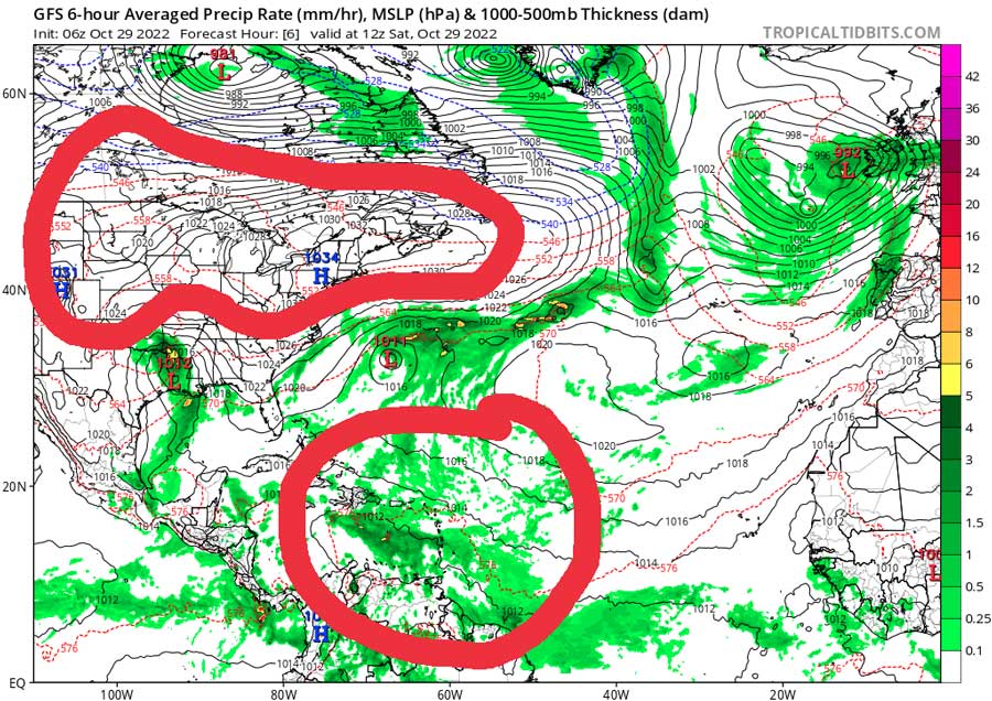
Saturday 7am WX map check out the 2 very different La Ninya air masses. The Northern Plains are so dry and the Caribbean so wet. Moisture levels down here are 20-30% higher than normal. Back in Texas, that weak low pressure is not getting any upper level kick to sweep into the gulf.

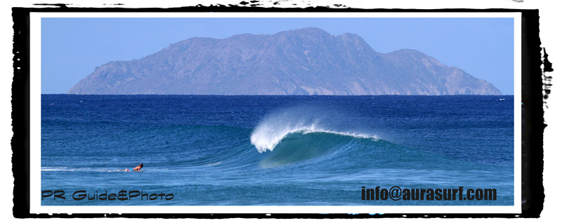
One of the images we will remember the most from 2020 WFL Hurricane Season. Luke Norris pulling in. Photo used with permission #jmax.
Now we’re in the last stretch which forecasters are saying it La Niña could go into February now. What it does for you guys is: It pulls the storm track up so instead of the storm track coming across Texas and into the southeast, going off of Hatteras the storm track usually is at a higher latitude near Michigan/Southern Canada and the northern plains. All summer long there was a high-pressure blocking any weather from the Gulf of Mexico. Then you get 1 horrible hurricane, Ian… Now during this time of year with La Niña what it does is it spreads out the cold fronts out so you can still get a really good cold front but it’ll most likely be flat in between for weeks. What La Niña has done for the Caribbean and this is why I think it’s flexing right now, it’s probably at its strongest point in the three years- it strengthens the high-pressure in the Central Atlantic and moisture piles up in the Caribbean as you can see on the map above. It’s just soup down here. All the weather from the Southeast US has collected and converged with trade flow from the Eastern Atlantic in the Caribbean basin around the bottom of that Bermuda high so whereas much of the US is in drought- the Caribbean is getting flooded. Even my friends in the Virgin Islands who usually don’t get too much rain are getting tons of rain. Puerto Rico has been flooding. The water quality here is as bad as I’ve ever seen it. Looking ahead for WFL I would expect infrequent cold fronts from now until New Year’s with probably one to three events per month, mostly back door fronts. You know- 1 to 2 foot hard angled north and the same thing for the Atlantic it’s not gonna be that stormy although there is one out there now. I do think once we get to January there’s usually a lot of northeast trade swell down here. The good thing is I guess that this pattern is going to eventually go away. If it does go neutral in the spring of 2023 I think the weather will have that Yin and Yang type of pent up action where it’s going to bounce back with lots of storms and lots of cold fronts with it. It will be really active and next hurricane season will probably be worse than this one, why? Because this season was very slow up until Fiona and Ian. That’s just my opinion, my speculation for this winter but in conclusion La Niña has not been good for gulf coast wave events and even Puerto Rico ocean storm surf. What do you think?


Need an attorney that understands you? Check in with Scott.
Sunday 7am Updater: Wave models show a 1ft wave for tomorrow so if you wanted to take your grom or LB and try and try and get wet. It shows up late morning mid day from the old Texas low that weakened and moved away. No real waves but a small line is possible mid day and on Monday. Bad news- Behind tomorrows 1ft wave a blocking high sets up to start November and a flat spell looks to be happening.
Friday 6am 10/28 Wave WX Update: Low pressure over Texas will dig and then move north today. High pressure ridges over Florida with East and NE flow. This pattern is making for more calm and quiet conditions. By tomorrow the Texas low is forecast to weaken and pull away from the gulf. No waves are expected. Late Sunday/Monday will have a small knee high longboard wave. Next week looks calm at this point. Check the EC forecast for surf chances. The Caribbean is pretty calm this weekend but supposed to have swell next week. Have a good weekend. I’ll try and update Sunday or Monday am.

info@aurasurf.com